| April 2026 Update: AWWU is currently completing emergency repairs to the sewer force main underlying the Fish Creek Estuary. This work is not related to the AMATS: Fish Creek Trail Connection project. |
Welcome to the project website for the Anchorage Metropolitan Area Transportation Solutions (AMATS): Fish Creek Trail Connection project. The Alaska Department of Transportation & Public Facilities (DOT&PF) in collaboration with the Municipality of Anchorage (MOA) plans to construct a new multi-use trail connection from Fish Creek Trail at Northern Lights Boulevard to the Coastal Trail in the vicinity of Fish Creek in Anchorage, Alaska.
This project will consist of the following components:
- Americans with Disabilities Act (ADA) Non-motorized facilities
- Drainage
- Excavation
- Coastal erosion protection
- Safety features
- Pavement
- Signing and striping
- Retaining walls
- Bridge
- Overlook areas
The AMATS: Fish Creek Trail Connection Project is managed by DOT&PF in collaboration with the MOA Parks and Recreation Department. MOA will own and maintain this trail after construction.
This website will continue to be updated as project information becomes available. Return for updates!
The project team is committed to inclusive public involvement throughout the project process. It is the policy of the Alaska Department of Transportation and Public Facilities DOT&PF that no one shall be subject to discrimination on the basis of race, color, national origin, sex, age, or disability, regardless of the funding source, including Federal Transit Administration, Federal Aviation Administration, Federal Highway Administration, Federal Motor Carrier Safety Administration, and State of Alaska funds. Title VI Nondiscrimination Policy: https://dot.alaska.gov/tvi_statement.shtml. To file a complaint, visit https://dot.alaska.gov/cvlrts/complaint.shtml.
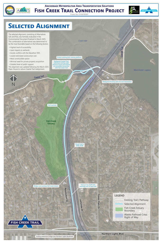
Selected Alignment
The project completed the environmental document in March 2025 which finalized the selected alignment highlighted below. The March 19th Open House #2 provided a status update and an opportunity for input on specific project elements as the project team advanced towards the 75% Design (Plans in Hand), the first draft of detailed design. The Plans in Hand submittal was completed November 2025, incorporating comments about the Coastal Trail realignment following Open House #2. The project team continues coordination with the Alaska Railroad, Marathon Pipeline, and other stakeholders as it advances the selected alignment to final design.
Detailed information about the alignment and the analysis that led to that its selection are available on the Resources page. Please contact the project team with questions or comments.
Site Map
Upcoming Events
April 2026
Trail Review
Urban Design Commission
Wednesday, April 29th, 2026
6:30 PM
Z.J. Loussac Library
Assembly Chambers
3600 Denali Street
Anchorage, AK 99503
More Information
To join the project email list, click below!

To submit comments on the design presented at Open House #2, click below!